I have a lot of exciting stuff up at PrintableWorldMap.net, including two new categories and 45 new printable maps. The brunt of these new additions will be especially great for astronomy and U.S. students, but there’s a little global geography and ancient history in there too.
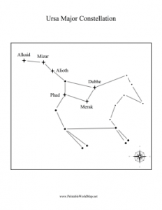
One of my new categories is constellation maps, which has star maps for avid stargazers and astronomers. There are dozens of major constellations featured here, including Ursa Major, Orion, Gemini, Cancer, and other constellations more commonly associated with horoscopes. You can see the orientation of the constellation, the brightest stars’ names, and imagined lines that make up the shape. Obviously, these change a bit depending on the season.
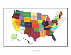
My other new category divides the United States up into regional maps based on state grouping. You can see the states that make up the Pacific or Atlantic coasts, the South, the Southwest, the Rocky Mountains, and more. Teachers can use these maps to assign projects based on regions.
Additionally, I also have a cute, colored map of the U.S., a map of zip codes and national parks, global maps of longitude and latitude, and maps of both Ancient Egypt and Ancient Greece.
All, told, there are around 200 different maps to choose from at PrintableWorldMap.net. There are some that are colored in, there are labeled maps, and then there are blank, line art maps. The latter can be helpful for projects and teaching, while the former can be great for memorization and celebrating culture. Each map is free to download and print as a PDF.